So it turns out that the usage of google maps is not easily possible anymore and you are bound to pay from the very first page view which uses it.
Setting up a new wordpress website for the local amateur observatory, the Hans-Zimmermann-Sternwarte in Braunschweig-Hondelage, I was looking for alternatives – and OSM has been on my radar for some time (and I have been using it somewhat, yet infrequently). A good time to take a more closer look at it and how to utilize it.
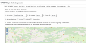
Seems there is a handy plug-in which connects OSM to wordpress. So let’s see how it looks:
That’s pretty nice for like playing around for 5 minutes for the first time. You can define up to 9 custom markers and you can choose from a variety of looks for them. But the interface in how to set markers is a bit unhandy, more complicated than seems necessary: You first have to define each marker in the separate „Marker erzeugen“ (create marker) tab. Then you have to select in the visible main tab whether to show none, one of them or all of them – but no possibility to choose 1,2 and 4.
You have seemingly pretty easy means to show tracks – something which will be interesting when it comes to documenting trips or hikes.
In summary I’m very pleased with it. 4.5 of 5 stars 🙂